This time is not really going to be about Italy again, but it’s still about human geography. We are going to be talking about the multiple nuclei model, the multiple nuclei model is a type of urban model that explain the economy of some specific cities.
The multiple Nuclei model is created by Chauncy Harris and Edward Ullman, it’s a model that’s based in Chicago in 1945. This model is mostly suitable for the big city, but the size of this model in the region might be different in real life because of urban sprawl. Urban is an area that is characterized by high human population density and the human features of the areas surrounding it. Urban sprawl is unchecked urban growth. It usually refers to the migration of people from cities to the low population land around it. Those people who move from the city to another place usually because they want to get better stander of living and have bigger land to live in.
The characteristics that the Multiple Nuclei Model has are:
- Land is flat.
- The resources are even distribution.
- Even distribution of people in residential areas, which means they save similar amount of land to use in the same region of residential.
- Even transportation costs, which means their transportation cost are similar through out the city.
There are also many other urban models, such as a Concentric Ring Model (created in 1923), Hoyt Sector Model (created in 1939), Multiple Nuclei Model (created in 1945), and Galactic City Model (created in 1960). Sometimes, a city fit into one model, but after a few decades, it developed into the other kind of city that the other kind of model can describe, such as Chicago. In 1939, Chicago’s a city that has a similar formation as Hoyt Sector Model, but it turns into more Multiple Nuclei Model like later. This is because of Urban Sprawl and the invention & develops of automobile, or transportation. In those days, the urban sprawl did a huge effect: a lot of buildings are spread out from the central business district, or CBD, and have multiple business centers, such as outlying business district. Also, the car ownership has increased in that time, so people can have greater movement and go around the city easily. This later on allow them to move further away from the CBD and still being able to go to where they want because of all these automobiles.
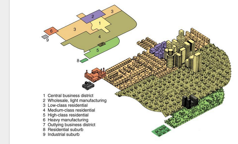
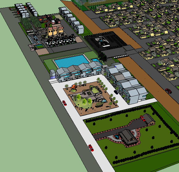
This picture shows the total amount of region that multiple nuclei model usually has, the name of those regions and a simple map of Multiple Nuclei Model.
This model is called multiple nuclei because it has more than one center for a specific type of area. First, where trade and business are taking place are not necessarily going to be the CBD, there are also other places where are doing this kind of thing, such as outlying business district. Second, for the place where people are making a product, it separated into three regions, which are the wholesale, light manufacturing region, heavy manufacturing region, and the industrial suburb.
Third, for the place where people lived in, there are four types, low-income residents, middle-income residential, high-income residential and residential suburb. Most of these happened are again, because of the invention of cars. So, when people who are working in the office, they don’t have to live very close CBD, they can go live in high income residential or the place middle and high income residential and have a better stander of living.
The major regions in this model are the ones that I had talked about: central business district, wholesale, light manufacturing region, low-income residential, middle-income residential, high-income residential, heavy manufacturing, outlying business district, residential suburb, and industrial suburb.
Central business district (CBD) is the business center of a city and the center point for transportation networks. Also, this is where most of the office work located at. In this region, there are many tall buildings, because it has higher density, even if the population is spreading out.
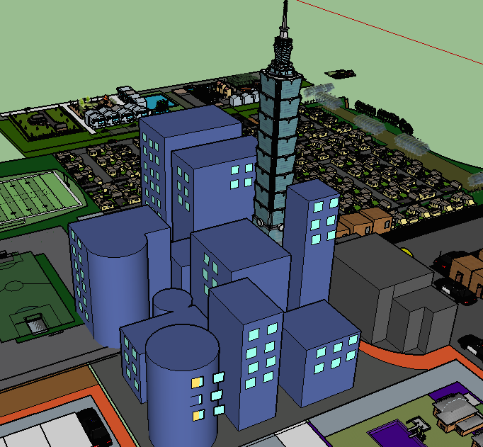
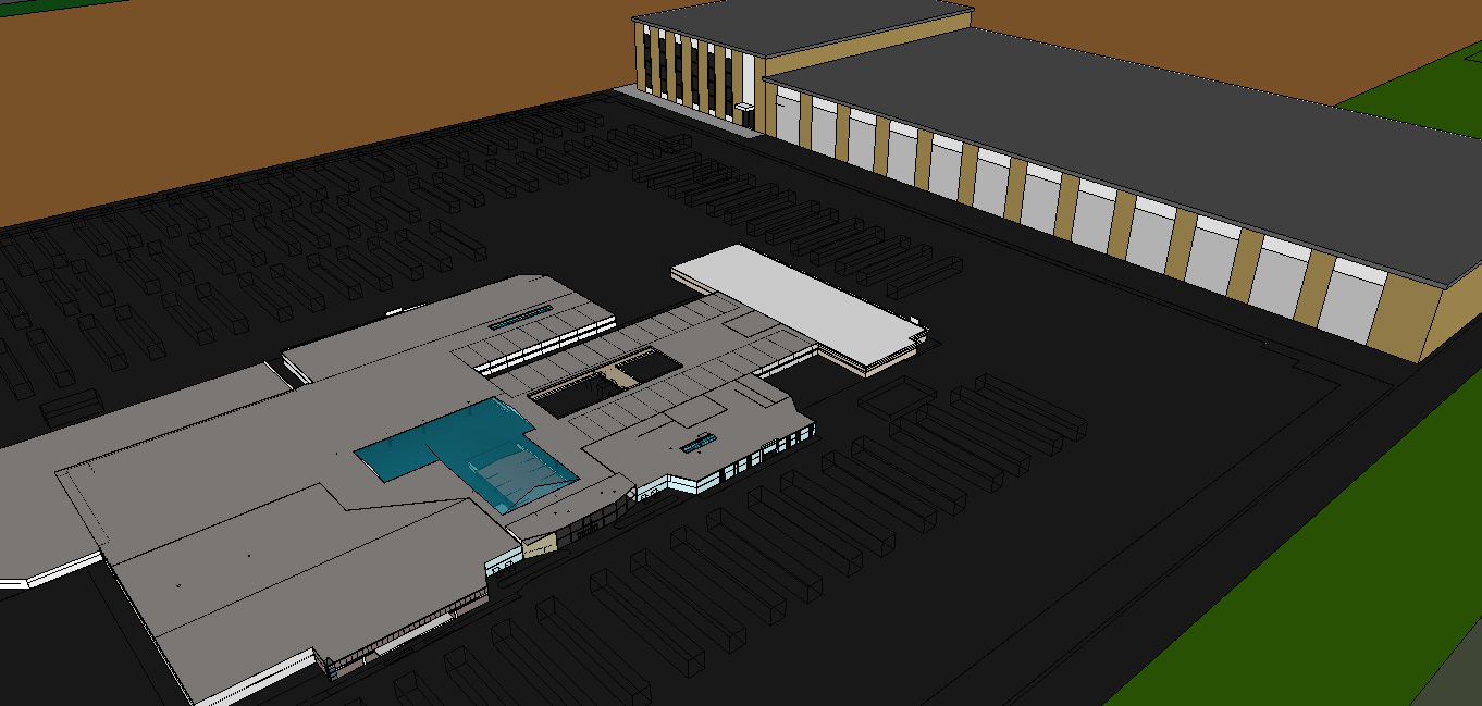
This is the example of CBD.
Wholesale, light manufacturing region is the region that has light industrial business in there. Light manufacturing usually produces a small product and things that will be used by the heavy manufacturing region. Also, because it’s close to the low-income residents, those people usually work in this region, and got low paid.
This is an example of wholesale, light-manufacturing region.
Low-income residential has the people with mostly low wage live in there. The people in there usually doesn’t have enough money to buy big houses or large lands, so their house is usually sticking together or has little space between them. Also, low-income residential usually has bad public security, so more the police go in there over time. The other thing to mention, if we see the map of this model, we can see that this region is closer to the facts, this is because these people usually don’t have enough money to buy an automobile, so if they live closer to the factory, they are able to walk there.
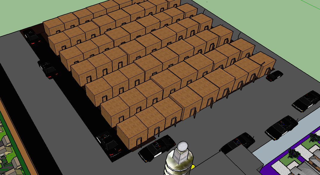
This is one part of low-income residential.
The people live in middle income residential have a better stander of living than low income residents. The houses that each family own in this region is usually larger than the people in lower class residential.

This is an example of house in middle income residential.
High income residential has the people with high wage or people how owns a company lives in there. This region has a better stander of living than middle-income residents and low-income residents, they have more things like swimming poor and some large park.
This is an example of high income residential.
Heavy manufacturing is a region that produce heavy or large product, mostly product that has steel, such as cars. Many people from low-income residents come here to work and get low pay. This region is far from the CBD and rest of residential area because it produces a huge amount of pollution, which lots of people don’t want to live or work with, at least they have no choice.
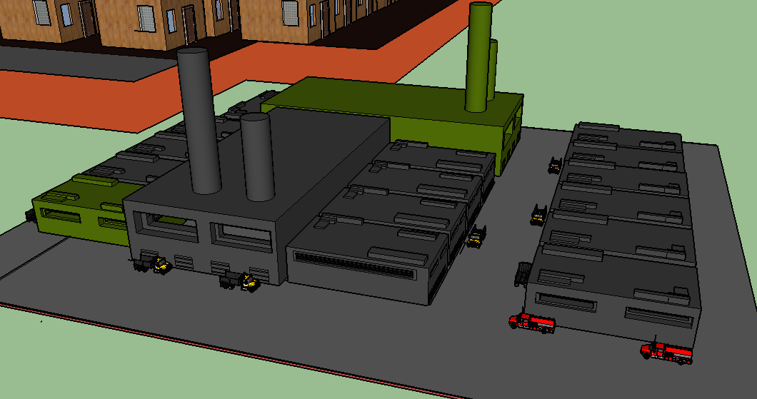
This is an example of heavy manufacturing region. We can see there are some cars set by the factory, those are used for transport the product or material.
Outlying business district is like a second CBD. The business that didn’t take place in CDB will take place in here.
This is an example of outlying business district.
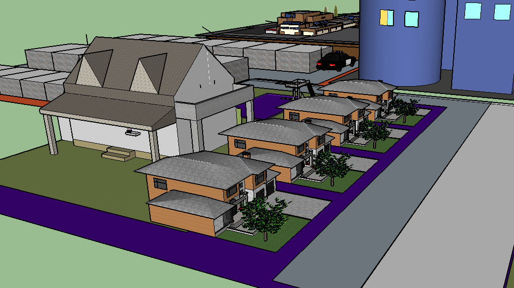
Residential suburb is residential area that spate away from other areas. In many times, it’s mix use, which means it have multiple functions.

This is an example of residential suburb.
Industrial suburb is a mixed type of industrial area that also spread away from the central city.
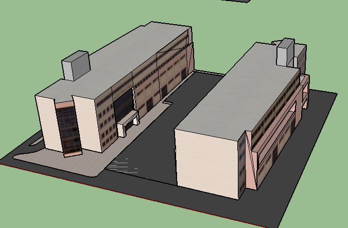
This is an example of industrial suburb.
If you click on: Multiple Nuclei Model, it will lead you to a file on google drive that I created and you are able to download it if you want.The program that I used to make this file is Google Sketch-Up personal project edition.
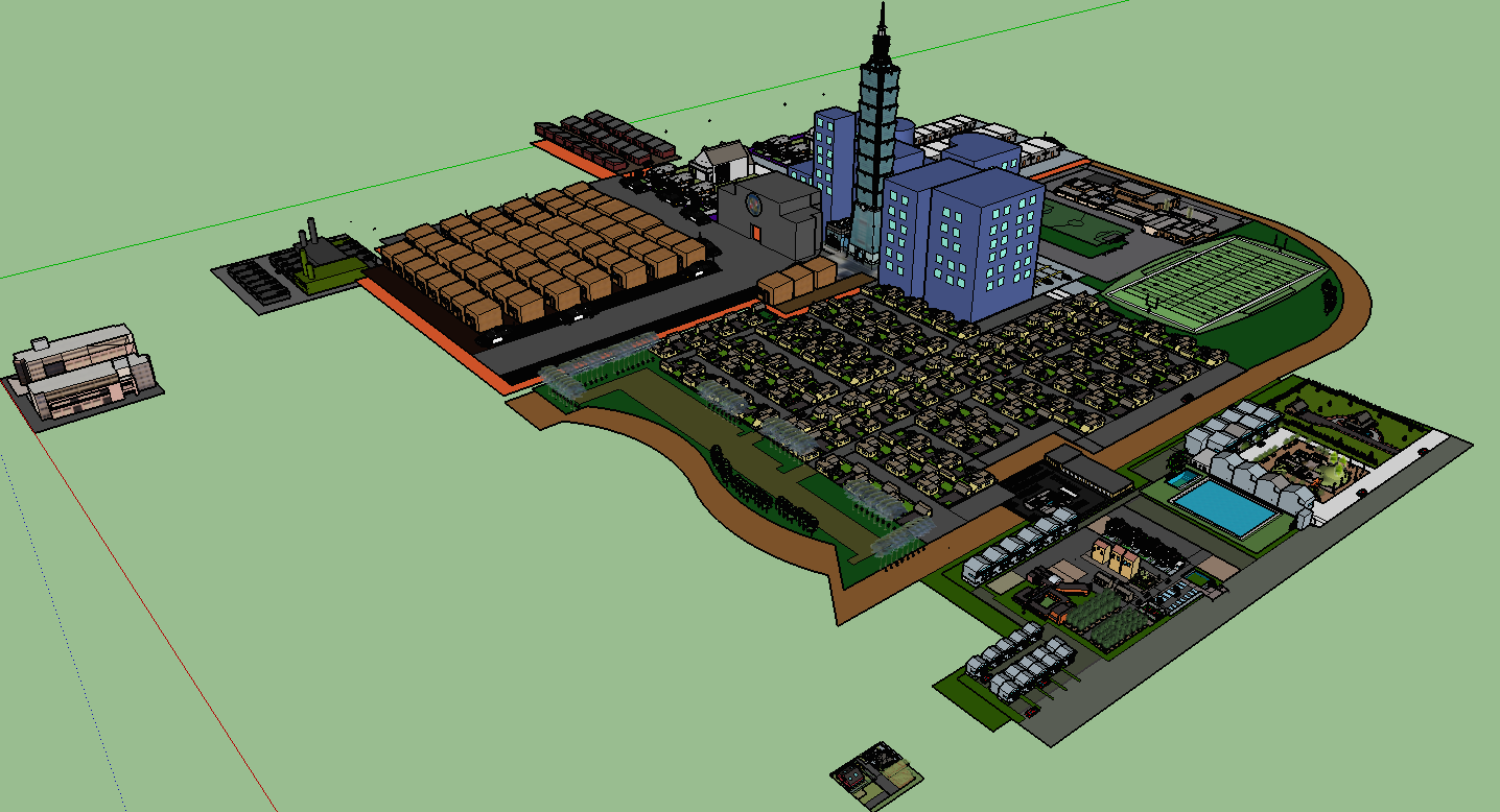
This is a multiple nuclei model that made by using google sketch up.
%MCEPASTEBIN%
